

How often Tsunami in Indonesia?
Last updated: 19 July 2006.
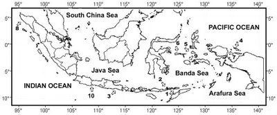
In periods of 1990-2006, 10 tsunami have occured in Indonesia. The map (Figure 1) shows the distribution of the tsunamis.
In periods of 1990-2006, 10 tsunami have occured in Indonesia. The map (Figure 1) shows the distribution of the tsunamis.
Figure 1. Tsunamis distribution in Indonesia in periode of 1990-2006.
1. Alor, Nusa Tenggara, 1991; 2. Flores, Nusa Tenggara, 1992;
3. Banyuwangi, East Java, 1994; 4. Biak, Papua, 1996; 5. Obi, North Maluku, 1998;
6. Banggai, North Maluku, 2000; 7. Manokwari, Papua, 2002;
8. Aceh, Nangroe Aceh Darussalam, 2004; 9. Buru, Maluku, 2006; 10. Pangandaran, West Java, 2006.
(Compiled from Fauzi and Ibrahim, 2002, Fig.1, no. 1-6; Setyawan, 2002, no. 7; and author's data, no. 8-10).
Regards,
Wahyu
posted by Wahyu Budi Setyawan | Saturday, May 06, 2006
|
0 comments
![]()