

Imprints of the 26 Desember 2004 Tsunami
Lebih dari setahun yang lalu tsunami melanda Banda Aceh. Pada awal Maret 2006 yang lalu, 2 - 10 Maret 2006, saya sempat berkunjung ke kota tersebut dan mencoba merekam jejak-jejak tsunami itu. Foto-foto berikut adalah beberapa diantaranya.
The following photographs were taken during my short visit to Banda Aceh, 2 - 10 March 2006.
.jpg)
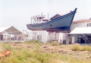
Balance (Photo 1). The fishing boat sit in balance on framework-wall of the house at Peunayong, Banda Aceh.
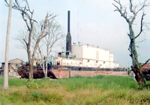
Power (Photo 2). Floating Power Plant at Punge, about 3 km from Ulee Lheu. Before the tsunami, the power plant was installed at Ulee Lheu. Now, it become one of many tourist attraction objects related to tsunami at Banda Aceh. Every day, it visited by much tourists.
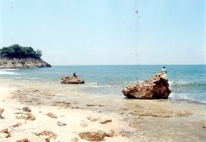
Excotic Blocks (Photo 3). The excotic blocks of coral reef boulder sitting on reef- flat at Lhok Nga coastal area, Banda Aceh. In Indonesia, we also can see the tsunami generated boulders on reef flat along the west coast of Java, Sunda Strait coast.
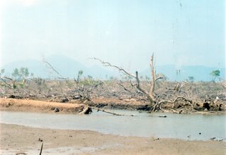
Mangrove (Photo 4). The mangroves (Rhizopora) were devastated by tsunami at Syiah Kuala coastal area, Banda Aceh. This fact bring us to a question "how can mangrove protect coastal area from tsunami hazard?". On the contrary, as we all know, much peoples belief that mangrove can protect coastal zone from the hazard. This contradiction lead us to question "how dense and thick of mangrove belts must exist along the coast before it can act as a protector?".
Regards,
Wahyu
posted by Wahyu Budi Setyawan | Wednesday, March 29, 2006
![]()
0 Comments:
Post a Comment
<< Home